⚠️ WARNING: Restricted Fire Season
The Fire Danger Rating System
A fire danger rating system should supply an objective answer to the question: 'What is the probability of a fire starting, spreading and doing damage today?' It enables fire managers to properly assess the levels of preparedness and the suppression resources needed to keep fire losses to a minimum. A fire danger rating system measures the variable elements which cause day to day changes in fire risk, and interprets the information gained.
The information is used to:
* define the fire season
* determine appropriate fire prevention measures
* assess the likelihood of fire occurring
* determine fire suppression response and resources
* inform the public
* make decisions to close areas at high risk
* issue or cancel burn permits
* plan and conduct controlled burns
| FWI Danger Levels Index |
| 0-7 |
8-16 |
17-23 |
24-32 |
32+ |
|
LOW -1- |
Moderate -2- |
High -3- |
Very High -4- |
Extreme -5- |
FIRE WEATHER INDEX (FWI)
The Fire Weather Index (FWI) System is the first part of the Canadian Forest Fire Danger Rating System (CFFDRS) introduced into New Zealand in 1980. It has proved to be a suitable fire danger rating system for this country. The FWI was evaluated for several seasons before it was introduced for the 1980-81 fire season.
The FWI is based on weather readings taken at noon standard time and rates fire danger at the mid afternoon peak from 14:00 - 16:00 pm. Weather readings required are:
* Air temperature (in the shade)
* Relative Humidity (in the shade)
* Wind speed (at 10 metres above ground level for an average over 10 minutes)
* Rainfall (For the previous 24 hours)
The Fire Weather Index has six components:
Three Fuel Moisture Codes:
1. Fine Fuel Moisture Code
2. Duff Moisture Code
3. Drought Code
Three Fire Behaviour Indices:
1. Initial Spread index
2. Build Up Index
3. Fire Weather Index
FWI CALCULATION
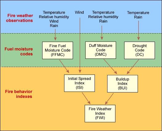
THE FIRE WEATHER INDEX CALCULATION STRUCTURE.
Interpretation of FWI Codes and Indices
To interpret the system the three fuel moisture codes and the three behaviour indices need to be understood. Each code and index is a numerical rating related to likely fire behaviour. The scales start at zero, and except for the Fine Fuel Moisture Code which has a maximum of 99, all are open-ended. Low ratings indicate high moisture content, and ratings rise as moisture content decreases. Ratings rise as fire weather becomes more severe.
Fuel Moisture Codes
The FWI System evaluates fuel moisture content and relative fire behaviour using past and present weather effects on ground level fuels. The moisture codes reflect the nett effects of daily moisture gains and losses.
FFMC: (Fine Fuel Moisture Code)
This is a numerical rating of the moisture content of surface litter and other cured fine fuels. It shows the relative ease of ignition and flammability of fine fuels. The moisture content of fine fuels is very sensitive to the weather. Even a day of rain, or of fine and windy weather, will significantly affect the FFMC rating. The system uses a time lag of two-thirds of a day to accurately measure the moisture content in fine fuels. The FFMC rating is on a scale of 0 to 99. Any figure above 70 is high, and above 90 is extreme.
DMC: (Duff Moisture Code)
DMC is a numerical rating of the average moisture content of loosely compacted organic layers of moderate depth. The code indicates the depth that fire will burn in moderate duff layers and medium size woody material. Duff layers take longer than surface fuels to dry out but weather conditions over the past couple of weeks will significantly affect the DMC. The system applies a time lag of 12 days to calculate the DMC. A DMC rating of more than 30 is dry, and above 40 indicates that intensive burning will occur in the duff and medium fuels. Burning off operations should not be carried out when the DMC rating is above 40.
DC: (Drought Code)
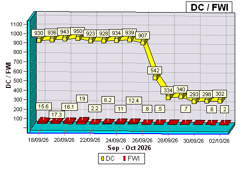
The DC is a numerical rating of the moisture content of deep, compact, organic layers. It is a useful indicator of seasonal drought and shows the likelihood of fire involving the deep duff layers and large logs. A long period of dry weather (the system uses 52 days) is needed to dry out these fuels and affect the Drought Code. A DC rating of 200 is high, and 300 or more is extreme indicating that fire will involve deep sub-surface and heavy fuels. Burning off should not be permitted when the DC rating is above 300.
Fire Behaviour Indices
The three behaviour indices are relative to the fuel moisture content. They indicate what a fire is likely to do. The lower the moisture content, the higher the Fuel Moisture Codes, and the higher the Fire Behaviour Indices - and the more active the fire will be.
ISI: (Initial Spread Index)
This indicates the rate fire will spread in its early stages. It is calculated from the FFMC rating and the wind factor.
The open-ended ISI scale starts at zero and a rating of 10 indicates high rate of spread shortly after ignition. A rating of 16 or more indicates extremely rapid rate of spread.
BUI: (Build Up Index)
This index shows the amount of fuel available for combustion, indicating how the fire will develop after initial spread. It is calculated from the Duff Moisture Code and the Drought Code.
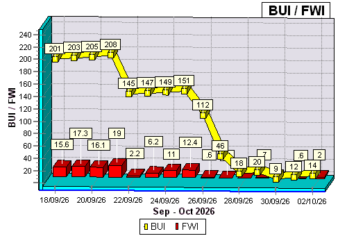
The BUI scale starts at zero and is open-ended. A rating above 40 is high, above 60 is extreme.
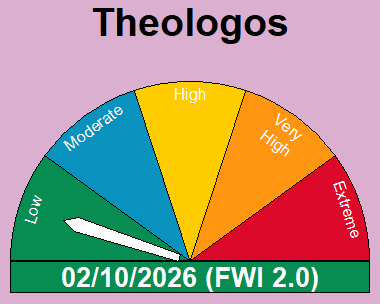
Last FWI: 2.0
Fire Weather index - FWI
Information from the ISI and BUI is combined to provide a numerical rating of fire intensity - the Fire Weather Index. The FWI indicates the likely intensity of a fire.
The FWI is divided into
The system ratings for High and Extreme are:
|
CLASS | FFMC | DMC | DC | ISI | BUI | FWI |
| HIGH | 70-90 | 30-40 | 200-300 | 10-16 | 40-60 | 17-31 | |
EXTREME | 90+ | 40+ | 300+ | 16+ | 60+ | 32+ |
FIRE DANGER CODES (FFDC, SFDC, GFDC)
The FWI is further refined into indices that represent the Fire Intensity likely in the three vegetation types (Forest, Scrub & Grasses). These three codes are divided into five fire danger classes (Low, Moderate, High, Very high & Extreme) and calculate the fire intensity in kilowatts per square metre (kw/m²).
|
CLASS | LOW | MODERATE | HIGH | VERY HIGH | EXTREME |
| INTENSITY | 0-10kw/m² | 11-500kw/m² | 501-2000kw/m² | 2001-4000kw/m² | 4000+kw/m² |
FFDC: (Forest Fire Danger Code)
Based on predicted generated "fire intensity (kw/m²)" in forest type vegetation (pine, beech). This code denotes how difficult it would be to control a fire in this vegetation type should one start. (Low, Moderate, High, Very High, Extreme)
SFDC: (Scrub Fire Danger Code)
Based on predicted generated "fire intensity (kw/m²)" in scrub type vegetation (manuka, gorse, broom). This code denotes how difficult it would be to control a fire in this vegetation type should one start. (Low, Moderate, High, Very High, Extreme)
GFDC: (Grass Fire Danger Code)
Based on predicted generated "fire intensity (kw/m²)" in grass type vegetation (dry grass, tussock). This code denotes how difficult it would be to control a fire in this vegetation type should one start. (Low, Moderate, High, Very High, Extreme)
INTERPRETING THE INFORMATION.
Moisture Codes
1. The moisture codes (FFMC, DMC and DC) indicate what fuels will be involved and their ease of ignition. This will vary during the season. Each code must be considered to assess potential burning characteristics.
Example: 1
FFMC = 86 DMC = 25 DC = 120
These ratings indicate:
* fine fuels will ignite easily
* fire will involve the light fuels and to a limited extent the medium and duff layer fuels
* fire will not become deep seated
Example: 2
FFMC = 86 DMC = 25 DC = 120
These ratings indicate:
* fine fuels will ignite easily
* fire will involve the light fuels and to a limited extent the medium and duff layer fuels
* fire will not become deep seated
Fire Behaviour Indices
2. The fire behaviour indices (ISI, BUI, FWI) indicate the likely initial spread, total fuel availability, and potential intensity.
Example: 3
ISI = 5 BUI = 120 FWI = 21
These ratings indicate:
* slow initial spread
* high volume of fuel available for combutstion
* potentially high level of fire intensity
In general terms, a hot, but slow moving fire. The type of fire likely to occur on a windless day in mid-summer after a long dry period.
Example: 4
ISI = 25 BUI = 10 FWI = 21
Note the same FWI as example 3.
These ratings indicate:
* extremely fast initial spread
* low volume of fuel available for combustion
* potentially high level of intensity
In general, a fast moving fire involving fine fuels only.
Likely to be either:
1. a fire in early spring of late autumn when medium and heavy fuels have a moisture content and winds are strong, or
2. a fire after rain on a day with strong winds
LAST 20 DAYS DATA
| Date | Temp
ºC | Humidity
% | Wind Speed
kmph | Rainfall
mm | FFMC | DMC | DC | ISI | BUI | FWI | FWI DC |
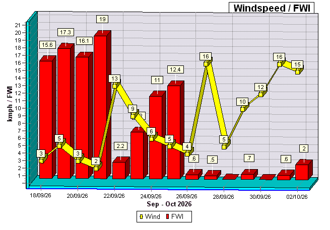
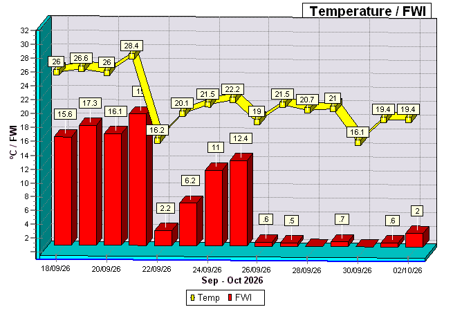
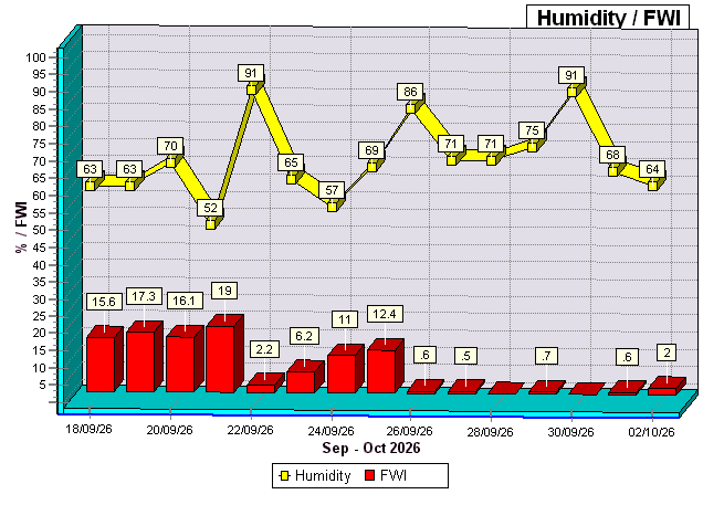
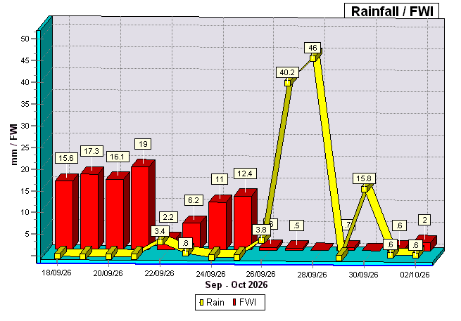
| 02/10/2026 | 19.4 | 64 | 15.0 | 0.60 | 77.0 | 7 | 302 | 1.8 | 14 | 2.0 | LW |
| 01/10/2026 | 19.4 | 68 | 16.0 | 0.60 | 60.6 | 6 | 298 | 0.9 | 12 | 0.6 | LW |
| 30/09/2026 | 16.1 | 91 | 12.0 | 15.80 | 25.5 | 5 | 293 | 0.0 | 9 | 0.0 | LW |
| 29/09/2026 | 21.0 | 75 | 10.0 | 0.00 | 62.1 | 11 | 340 | 0.8 | 20 | 0.7 | LW |
| 28/09/2026 | 20.7 | 71 | 5.0 | 46.00 | 36.2 | 10 | 334 | 0.0 | 18 | 0.0 | LW |
| 27/09/2026 | 21.5 | 71 | 16.0 | 40.20 | 47.7 | 26 | 542 | 0.3 | 46 | 0.5 | LW |
| 26/09/2026 | 19.0 | 86 | 4.0 | 3.80 | 50.5 | 66 | 907 | 0.2 | 112 | 0.6 | LW |
| 25/09/2026 | 22.2 | 69 | 5.0 | 0.00 | 83.5 | 95 | 939 | 2.2 | 151 | 12.4 | MD |
| 24/09/2026 | 21.5 | 57 | 6.0 | 0.00 | 81.8 | 93 | 934 | 1.9 | 149 | 11.0 | MD |
| 23/09/2026 | 20.1 | 65 | 9.0 | 0.80 | 71.4 | 91 | 928 | 1.0 | 147 | 6.2 | LW |
| 22/09/2026 | 16.2 | 91 | 13.0 | 3.40 | 52.6 | 90 | 923 | 0.4 | 145 | 2.2 | LW |
| 21/09/2026 | 28.4 | 52 | 2.0 | 0.00 | 87.9 | 143 | 950 | 3.5 | 208 | 19.0 | HI |
| 20/09/2026 | 26.0 | 70 | 3.0 | 0.00 | 86.1 | 141 | 943 | 2.8 | 205 | 16.1 | HI |
| 19/09/2026 | 26.6 | 63 | 5.0 | 0.00 | 86.1 | 139 | 936 | 3.1 | 203 | 17.3 | HI |
| 18/09/2026 | 26.0 | 63 | 3.0 | 0.00 | 85.7 | 137 | 930 | 2.7 | 201 | 15.6 | MD |
| 17/09/2026 | 25.4 | 61 | 8.0 | 0.00 | 84.6 | 136 | 923 | 3.0 | 198 | 16.8 | HI |
| 16/09/2026 | 25.2 | 62 | 11.0 | 2.00 | 78.9 | 134 | 917 | 1.8 | 196 | 11.3 | MD |
| 15/09/2026 | 25.8 | 59 | 11.0 | 0.00 | 87.2 | 189 | 911 | 5.0 | 249 | 24.9 | VH |
| 14/09/2026 | 26.3 | 60 | 8.0 | 0.00 | 87.2 | 187 | 905 | 4.3 | 247 | 22.4 | HI |
| 13/09/2026 | 27.3 | 68 | 9.0 | 0.00 | 87.2 | 185 | 898 | 4.5 | 245 | 23.1 | VH |
GRAPHS
Wind to FWI
Temp to FWI
Humidity to FWI
Rain to FWI
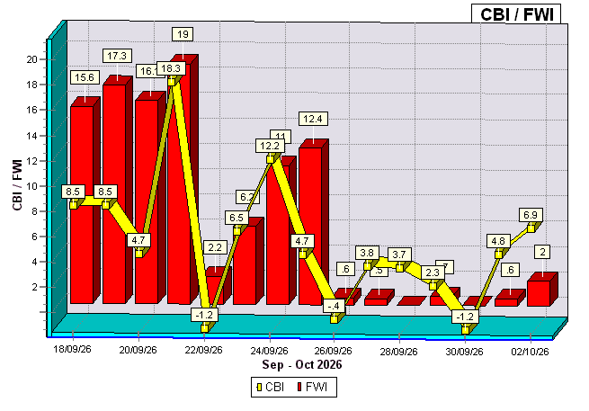
CBI to FWI
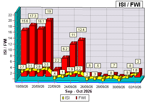
Initial Spread Index to FWI
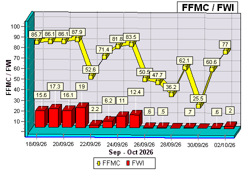
Fine Fuel Moisture Code to FWI
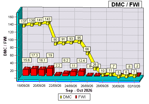
Duff Moisture Code to FWI
OTHER FIRE WEATHER INDEXES
The Chandler Burning Index (CBI), Angstrom Index and Fire Moisture Index (FMI) are other Fire Rating Systems developed in North America and Scandinavia.
CBI (Chandler Burning Index)
The Chandler Burning Index (CBI) is a Fire Rating System primarily used in North America.
It uses the air temperature and relative humidity to calculate a numerical index of fire danger.
That number is then equated to the Fire Danger severity of either extreme, very high, high, moderate, or low.
It's based solely on weather conditions, with no adjustment for fuel moisture.
In FWICalc daily CBI ratings are calculated, and an averaged 30 day historical rating is also calculated.
Daily CBI = (0.0167 * (104.5 - (1.373 * H) + (0.54 * T)) * (124 * Power(10,(-0.0142 * H))))
where H = Relative Humidity as % (0-100)
and T = Temperature in Degrees Celcius.
In the United States the National Weather Service calculates a 30 day Chandler Burning Index based on forecasted weather conditions for the month.
Monthly = (((110 - 1.373*H) - 0.54 * (10.20 - T)) * (124 * power(10,(-0.0142*H))))/60
where H = Relative Humidity as % (0-100)
and T = Temperature in Degrees Celcius.
CBI Fire Danger Severity Indexes
| CBI Danger Codes |
|
LOW -1- |
Moderate -2- |
High -3- |
Very High -4- |
Extreme -5- |
LOW <50
Fuels do not ignite readily from small firebrands although a more intense heat source, such as lightning, may start fires in duff or punky wood. Fires in open cured grasslands may burn freely a few hours after rain, but woods fires spread slowly by creeping or smoldering, and burn in irregular fingers. There is little danger of spotting.
MODERATE 50-75
Fires can start from most accidental causes but, with the exception of lightning fires in some areas, the number of starts is generally low. Fires in open cured grasslands will burn briskly and spread rapidly on windy days. Timber fires spread slowly to moderately fast. The average fire is of moderate intensity, although heavy concentrations of fuel, especially draped fuel, may burn hot. Short-distance spotting may occur, but is not persistent. Fires are not likely to become serious and control is relatively easy.
HIGH >75-90
All fine dead fuels ignite readily and fires start easily from most causes. Unattended brush and campfires are likely to escape. Fires spread rapidly and short-distance spotting is common. High-intensity burning may develop on slopes or in concentrations of fine fuels. Fires may become serious and their control difficult unless they are attacked successfully while small
VERY HIGH >90-<97.5
Fires start easily from all causes and, immediately after ignition, spread rapidly and increase quickly in intensity. Spot fires are a constant danger. Fires burning in light fuels may quickly develop high intensity characteristics such as long-distance spotting and fire whirlwinds when they burn into heavier fuels.
EXTREME 97.5+
Fires start quickly, spread furiously, and burn intensely. All fires are potentially serious. Development into high intensity burning will usually be faster and occur from smaller fires than in the very high fire danger class. Direct attack is rarely possible and may be dangerous except immediately after ignition. Fires that develop headway in heavy slash or in conifer stands may be unmanageable while the extreme burning condition lasts. Under these conditions the only effective and safe control action is on the flanks until the weather changes or the fuel supply lessens.
ANGSTROM INDEX (Angstrom)
The Angtstrom Index (Angstrom) is used primarily in Sweden, it uses the air temperature and relative humidity to calculate a numerical index of fire danger. That number is then equated to the Fire Danger severity of either Extreme, High, Moderate, or Low. It's based solely on weather conditions, with no adjustment for fuel moisture.
The lower the number, the higher the fire risk.
> 4.0 Fire occurrence unlikely
4.0 - 2.5 Fire conditions unfavourable
2.5 - 2.0 Fire conditions favourable
< 2.0 Fire occurrence very likely
Angstrom Index = (H/ 20)+ ((29 ?T) /10)
where H = Relative Humidity as % (0-100)
and T = Temperature in Degrees Celcius.
FUEL MOISTURE INDEX (FMI)
The Fuel Moisture Index (FMI) is very basic but showed in a study presented by its developer Sharpes a very good
performance in comparison with other fuel moisture indices. It uses the air temperature and relative humidity to calculate a numerical index of fire danger. No fire danger classification exists for this index.
The lower the number, the higher the fire risk.
FMI = 10 - 0.25 (T - H)
where H = Relative Humidity as % (0-100)
and T = Temperature in Degrees Celcius.
FOREST FIRE DANGER INDEX (FFDI)
The Forest Fire Danger Index (FFDI) was developed in the 1960s by CSIRO scientist A.G. McArthur to measure the degree of danger of fire in Australian forests. The index combines a record of dryness, based on rainfall and evaporation, with meteorological variables for windspeed, temperature and humidity.
A FFDI of between 12 and 25 on the index is considered a "high" degree of danger, while a day having a danger rating of over 50 is considered an "Severe" fire danger rating. Above this level in 2010 a distinction was made between Forest and Grassland fuels. For Forest fuels, an FDI over 75 is categorised as "Extreme" and over 100 as "Catastrophic" (In Victoria the alternate rating name of "Code Red" has been adopted). For Grassland Fuels the threshold FDI values for the Extreme and Catastrophic Ratings was increased to 100 and 150 respectively.
0-11 Low to Moderate | 12–25: High | 26–49: Very High | 50–74: Severe | 75–99: Extreme | 100+: Catastrophic
Temperature (T): Relative Humidity (H): Wind Speed (V): Drought Factor (D):
GRASSLAND FIRE DANGER INDEX (GFDI)
The Grassland Fire Danger Index (GFDI) is calculated from air temperature, relative humidity and wind speed. It also varies according to the greeness or curing of the pasture. It provides a figure directly related to the chances of a fire starting, its rate of spread, difficulty of control and the amount of damage it will do. The formula used in FWICalc is generally for Australian conditions, but can be adapted by varying the environment variables for any part of the world.
Temperature (T): Relative Humidity (H): Wind Speed (V)
BYRAM-KEETCH DROUGHT INDEX & DROUGHT FACTOR (BKDI - DF)
The Byram-Keetch Drought Index (BKDI) attempts to measure the amount of precipitation necessary to return the soil to full field capacity. It is a closed system ranging from 0 to 203 units (0 - 800 imperial) and represents a moisture regime from 0 to 203 millimetres (0 - 8 inches) of water through the soil layer. At 203 millimetres (8in) of water, the KBDI assumes saturation. Zero is the point of no moisture deficiency and 203 (800) is the maximum drought that is possible. At any point along the scale, the index number indicates the amount of net rainfall that is required to reduce the index to zero, or saturation.
The inputs for KBDI are weather station latitude, mean annual precipitation, maximum dry bulb temperature, and the last 24 hours of rainfall. Reduction in drought occurs only when rainfall exceeds 5mm (0.20 inch) (called net rainfall).
Drought Factor (DF): A key component of the FFDI is the modelling of the dryness of the fuel. This is expressed by the Drought Factor (DF), which ranges from 0 to 10. If this is multiplied by 10 and called a percent, it gives the percentage of fine fuel that would be removed by a fire under the current conditions.
The DF is based on recent rainfall and on the Byram-Keetch Drought Index (BKDI).
0–200 (Wet/Low Risk):Soil and surface litter are moist; minimal fire potential.
200–400 (Moderate Risk): Lower litter and duff layers are drying; fires burn surface fuels moderately.
400–600 (High Risk): Organic soil layers dry out and burn actively; increased fire intensity.
600–800 (Extreme Risk): Severe to extreme drought; high-intensity fires with unpredictable behavior and rapid spread.
Max Temperature (T): 24h Rainfall (R): Mean Annual Rainfall: Station latitude
|